Get Data
Research Sites web services include OGC WMS, WFS and Geoservices REST formats. The BAID archive has been transferred to AON

Allison Gaylord and Craig Tweedie. 2019. Barrow Area Information Database (BAID) Research Sites and Ancillary Geospatial Layers, North Slope, Alaska, 2000-2019. Arctic Data Center. doi:10.18739/A2RF5KG0P.
Julia Collins. 2017. Barrow Area Information Database (BAID) data services prototype. Arctic Data Center. doi:10.18739/A2JF8N.
Craig E. Tweedie and Julia Collins. 2014. Collaborative Research – Development and innovation of the Barrow Area Information Database (BAID): A cyberinfrastructure that supports arctic science, outreach and education. Arctic Data Center. urn:uuid:3b71aff0-3945-4091-93b0-73798a148206.
Allison Graves Gaylord and Craig E. Tweedie. BAID: NARL BAR flights Index by Quad (1948-49). Arctic Data Center. doi:10.5065/D6222RWR.
Allison Graves Gaylord. Barrow Area Information Database (BAID) Geospatial Data Sets, Barrow, AK, USA. Arctic Data Center. doi:10.5065/D6VT1Q75.
Craig E. Tweedie and Allison Graves Gaylord. Barrow Area Remote Sensing – BAID Power Poles. Arctic Data Center. doi:10.5065/D6BV7DQP.
Allison Graves Gaylord and Craig E. Tweedie. BAID: RADARSAT and ERS satellite SAR Images. Arctic Data Center. doi:10.18739/A2JW7R.
Craig E. Tweedie. Barrow Area Remote Sensing – BAID Be Research Sites. Arctic Data Center. doi:10.5065/D61G0JD2.
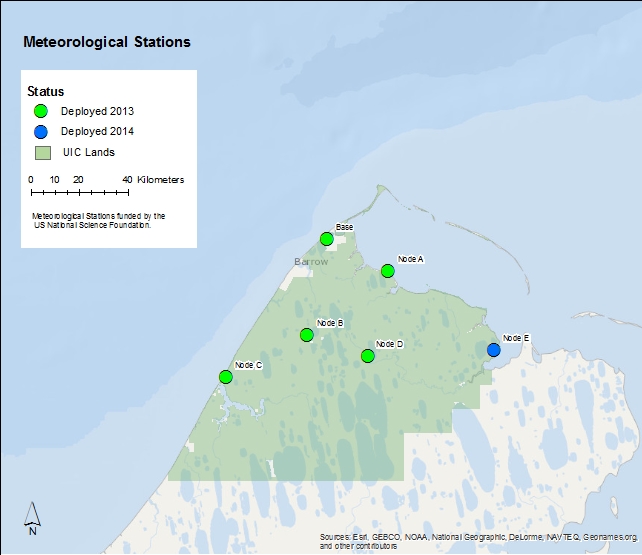
Barrow Meteorological Data